 Lebanese Ministry of Information
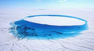
The 3.5 trillion tons of Greenland’s ice sheet that has melted over the past decade has raised global sea levels by 1 centimeter and is heightening worldwide flood risks, new research showed on Monday.
The ice sheet atop the world’s largest island contains enough frozen water to lift oceans some 6 meters globally, and extreme melting events there have been increasing in frequency for at least 40 years.
Writing in the journal Nature Communications, researchers said that Greenland’s meltwater runoff had risen by 21% over the past four decades.
Lead author Dr Thomas Slater, a Research Fellow in the Centre for Polar Observation and Modelling at the University of Leeds maintained:
“As we’ve seen with other parts of the world, Greenland is also vulnerable to an increase in extreme weather events.
“As our climate warms, it’s reasonable to expect that the instances of extreme melting in Greenland will happen more often – observations such as these are an important step in helping us to improve climate models and better predict what will happen this century.”
The study, funded by the European Space Agency’s (ESA) as part of its Polar+ Surface Mass Balance Feasibility project, used measurements from the ESA’s CryoSat-2 satellite mission.
The study reveals that over the past decade (2011 to 2020), increased meltwater runoff from Greenland raised the global sea level by one centimetre. One third of this total was produced in just two hot summers (2012 and 2019), when extreme weather led to record-breaking levels of ice melting not seen in the past 40 years.
Raised sea levels caused by ice melt heightens the risk of flooding for coastal communities worldwide and disrupts marine ecosystems in the Arctic Ocean that indigenous communities rely on for food.
It can also alter patterns of ocean and atmospheric circulation which affect weather conditions around the planet.
During the past decade, runoff from Greenland has averaged 357 billion tonnes per year, reaching a maximum of 527 billion tonnes of ice melt in 2012, when changes in atmospheric patterns caused unusually warm air to sit over much the ice sheet. This was more than twice the minimum runoff of 247 billion tonnes that occurred in 2017.
The changes are related to extreme weather events, such as heatwaves, which have become more frequent and are now a major cause of ice loss from Greenland because of the runoff they produce.
These first observations of Greenland runoff from space can also be used to verify how climate models simulate ice sheet melting which, in turn, will allow improved predictions of how much Greenland will raise the global sea level in future as extreme weather events become more common.
Study co-author Dr Amber Leeson, Senior Lecturer in Environmental Data Science at Lancaster University, said:
“Model estimates suggest that the Greenland ice sheet will contribute between about 3 and 23 cm to global sea level rise by 2100.
“This prediction has a wide range, in part because of uncertainties associated with simulating complex ice melt processes, including those associated with extreme weather. These new spaceborne estimates of runoff will help us to understand these complex ice melt processes better, improve our ability to model them, and thus enable us to refine our estimates of future sea level rise.”
The study reveals that satellites are able to provide instant estimates of summer ice melting, which supports efforts to expand Greenland’s hydropower capacity and Europe’s ambition to launch the CRISTAL mission to succeed CryoSat-2…
AFP