 Lebanese Ministry of Information
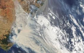
Among the many apocalyptic scenes from the Australian bush fires has been the presence of explosive, towering clouds appearing in the skies above the fire zones of southeastern Australia. These clouds, the most fearsome of which is known as pyrocumulonimbus, or pyroCb for short, are fire-generated thunderstorms.
Their presence is an indication that a fire is exhibiting extreme behavior, such as spreading quickly beyond containment lines, switching its direction of movement, and even whipping up fire whirls and full-fledged fire tornadoes.
Passengers aboard a Qantas Airlines flight to Canberra learned about the extraordinary forces involved in these clouds over the weekend, when their aircraft accidentally flew through one at high altitude. According to an ABC News account of the flight, the sky outside the aircraft’s windows turned bright orange, then pitch black as jarring updrafts shook the plane.
“It just got grayer and grayer,” passenger Matt McIntyre told ABC. “There was one guy sort of swearing. … I heard people down the front vomiting.”
Another passenger told the TV network that it was “the scariest flight” he had ever taken. “It was orange outside of the window, then suddenly it was black, and then the turbulence hit,” he said.
Fires as a source of convection
The Australian bush fires have been so intense that they’ve lofted smoke particles all the way into the stratosphere, in part through these clouds that in some cases look more like explosions. Once in the stratosphere, which is the layer of the atmosphere above where most weather occurs, in the troposphere, these particles can travel thousands of miles and even influence regional and global climate.
Neil Lareau, a meteorologist at the University of Nevada at Reno who researches fire-induced clouds, said he has never seen an outbreak of pyrocumulonimbus clouds as extensive and long-lasting as they have been during the ongoing Australia fire crisis. “The scope of the fires, I’ve just never seen anything like it,” he said in an interview, noting that these blazes have covered far more ground than anything seen in California, for example. “It’s a much scarier fire environment in a lot of ways.”
These behemoth clouds form when a nonatmospheric source of heat, most commonly from wildfires or volcanic eruptions, can locally create or enhance an updraft. It’s an effect occasionally vigorous enough to produce its own thunderstorm.
In these instances, pyrocumulonimbus clouds can tower to altitudes approaching 10 miles or more. Their plumes are composed of an ashy soot and water vapor. The water vapor helping the clouds grow taller can come from liquid water trapped in vegetation scorched on the ground as well as from latent heat release in the atmosphere. But the clouds often feature comparatively little rain, making them tough to spot and gauge using aircraft radars.
The most intense pyrocumulonimbus updrafts can be on par with or even stronger than those observed in the supercell thunderstorms that prowl the High Plains in the United States each spring.
According to Lareau, there have been direct measurements of updrafts as strong as 70 to 130 mph across a wide area, about half a mile in diameter, above a major wildfire. This data was gathered by a plane that, like the Qantas flight, accidentally flew into the base of such a cloud.
“These updrafts really rival some of the strongest updrafts you’ll encounter in atmospheric convection of any kind,” Lareau said.
In addition to the air rising rapidly, downdrafts of 60 mph can cause severe turbulence and pose risks for some aircraft. Avoiding such fire-generated clouds in areas that have a large expanse of smoke, such as southeastern Australia lately, can be challenging, he said, because the radar systems aircraft carry to spot thunderstorms don’t detect such clouds very well.
“Nose cone radar did not provide a signal comparable to what you would see from a thunderstorm updraft of that severity,” Lareau said of the aircraft that measured the updraft intensities. “It’s not clear that that threat to aviation from these things is widely known.”
On the ground, though, these clouds are just as violent. Abundant lightning has been observed from these clouds in Australia, Lareau said.
On occasion, pyrocumulonimbus clouds can take on a life of their own, becoming separated from the heat source that gave rise to them. Other times, pyrocumulonimbus clouds can produce severe weather — including flooding, muddy rain, hail (often discolored) and damaging downdraft winds. One such storm blew up over the Texas Panhandle after the Mallard Fire on May 11, 2018.
On extreme occasions and in the right environment, pyrocumulonimbus clouds can even take on the characteristics of a supercellular thunderstorm. One such storm produced a deadly EF-3 tornado that killed four people during the Canberra bush fires in 2003. More recently, a violent fire tornado killed several people near Redding, Calif., on July 26, 2018, during the Carr Fire.
Preliminary reports suggest that a potential fire tornado may have been to blame in an accident that killed a firefighter in New South Wales on Dec. 30.
Perhaps the most common and dangerous hazard posed by pyrocumulonimbus clouds is the potential for rapid fire growth and erratic fire behavior.
If a pyrocumulonimbus cloud’s updraft becomes organized enough, inflow winds at times exceeding 80 mph can fuel a raging inferno. Moreover, there comes a point at which the pyrocumulonimbus cloud is no longer subject to local weather influences, but rather becomes the predominant local weathermaker.
When that happens, the pyrocumulonimbus cloud can effectively become a firestorm. Unpredictable and chaotic winds can yield erratic fire behavior, catching fire personnel and the public alike off guard. Meanwhile, the fire’s updraft pulls air from all around into it, causing the added oxygen to fuel combustion even further.
Firestorms can cause fire fronts to surge, and carry embers far from the initial blaze. Lightning from the parent pyrocumulonimbus cloud can ignite new fires downwind, beneath the cloud’s hulking electrified anvil.
A firestorm swallowed a weather station in Cabramurra, Australia, on Saturday. Temperatures spiked to 158 degrees while winds gusted as high as 80 mph. Miraculously, the instruments continued recording. Temperatures jumped from 90 degrees to 124 degrees in 13 minutes shortly after 4 p.m. Saturday, finally subsiding back to 92 degrees by 6 p.m. About the reading, the Bureau of Meteorology stated in a tweet that the weather station “ended up between intense pyro-cumulonimbus over a fire on one side & new ignitions on the other … & this is the result.”
The Washington Post