 Lebanese Ministry of Information
Lebanon, with Beirut as its capital, covers a total surface area 0f 10,452 square kilometers. It is located on the eastern coast of the Mediterranean Sea between latitude 33 and 35 N and longitude 35 and 36 E. It is bordered on the north and east by Syria and on the south by the Palestinian Occupied territories. The country is roughly rectangular in shape becoming narrower towards the south and the farthest north. Its widest point is 88 kilometers and its narrowest is 32 kilometers.
The physical geography of Lebanon is influenced by natural systems that extend outside the country. Thus, the Bekaa valley is part of the Great Rift system which stretches from Southern Turkey to Mozambique in Africa.
A major feature of Lebanese topography is the alternation of low lanes and high land running in a parallel manner with a north-to-south orientation. There are four longitudinal strips between the Mediterranean Sea and Syria. Which are from west to east as follows:
– A flat and narrow coastal strip (maritime plain) parallel to the Mediterranean Sea
– The Mount-Lebanon chain
– The Bekaa Valley (Central plateau)
– The Anti-Lebanon Mountains Chain
Lebanon is located at the meeting point of the World’s three old continents: Africa, Asia and Europe, and over the centuries, it has been the crossroads of many civilizations whose traces may still be seen today. Lebanon enjoys a moderate Mediterranean climate with mild rainy winters and long warm and humid summers; and a topography that ranges from stunning scenic coastlines offering a variety of water sports to mountain slopes ideal for skiing, hiking and paragliding. The historical and archaeological sites, pleasant climate and natural beauty made Lebanon a country widely regarded as a “piece of Heaven on Earth”.
Area and Boundaries
total: 10, 452 km 2
land: 10, 230km 2
water: 170 km2
Land boundaries
total: 454 km
border countries: Palestine 79 km; Syria 375 km
Coastline: approximately 238 km square
Maritime claims: territorial sea 12 nmi
Elevation extremes:
lowest point: Mediterranean Sea (0 m) sea level
highest point: Qurnat el Sawda (3,088 m)
Major cities: Tripoli, Sidon, Tyre, Zahleh, Baalbeck and Byblos
Rivers and Lakes: Litani River, Hasbani River, Asi River; Lake Qaraoun, Lake Yammouneh
Airports: Beirut Rafic el Hariri International Airport, Riyak air base and Qelayat
Main Seaports: Beirut, Tripoli, Sidon, Tyre in addition to other touristic and commercial ports
Demographics
Lebanon is a mosaic of 18 officially recognized coexisting religious groups.
Population: around 4, 5 million
Growth rate: 1, 7%
Density: 431 kilometer
Urban population: 89%
Literacy rate: 90%
Labor force: 1, 6 million
Official language: Arabic (commonly spoken languages include French, English and Armenian)
Local Time: GMT +02 and GMT +03 (April to September)
Currency: (monetary unit) Lebanese Pound (LBP) one dollar is almost equal to LL 1500 depending on exchange rate
Calling code: country code international dialing +961 followed by an area code, then cell phone number or landline
Official Holidays
Independence Day, New Year’ s day, Christmas, Islamic New Year, Ashoura, St. Maroun’s Day, Prophet’s Mohammed’s birthday, Good Friday, Easter, Labor Day, Martyrs’ and Press Day, Resistance and Liberation Day (25 May), Virgin Mary Assumption, Eid Al Fitr, Eid Al Adha
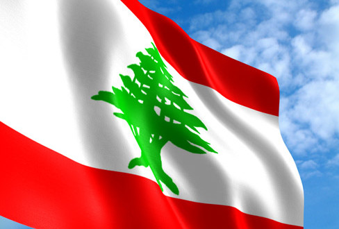
Lebanese Flag
The Lebanese flag is formed of three horizontal stripes: a white stripe between two red ones. The width of the white stripe should be equal to two times a red one (ratio 1:2:1). The green cedar in the middle touches each of the red stripes and its width is one third the width of flag. The red color signifies the Lebanese martyrs’ blood in the struggle for independence. The white color represents Lebanon’s snowcapped mountain peaks; symbol of purity and peace. The cedar drawn from the Lebanese mountains is a symbol of holiness, immortality, steadiness and eternity.